Southwest Montana Avalanche Advisory
Skiers, snowboarders, and snowmobilers rejoice. Area mountains have recieved anywhere from one to two feet of new snow for you to try all of your new toys out on. That also leads to considerable avalanche danger. Here's the latest advisory from the Gallatin National Forest Avalanche Center.
The northern Madison Range:
The mountains around Big Sky have received over 1 ft of snow during the last 48 hours, and ski patrols on Lone Mountain have easily triggered slab avalanches on wind loaded slopes. At Moonlight Basin, the ski patrol triggered one avalanche that broke on a layer of surface hoar buried 2 ft deep. With plentiful new snow and sufficient wind (blowing SW during the first half of the storm then switching to the N and E), avalanches occurring in the new snow are likely. Many slopes contain a layer of surface hoar buried 2 feet deep that will also be a problem. Around Big Sky the key will be to find low angle slopes lacking both wind deposited snow and the buried surface hoar layer. For today, the avalanche danger is HIGH on all slopes that are wind-loaded. All other slopes have a CONSIDERABLE danger.
The Bridger Range, southern Madison and southern Gallatin Ranges, the mountains around Cooke City, the Lionhead area near West Yellowstone and the Washburn Range:
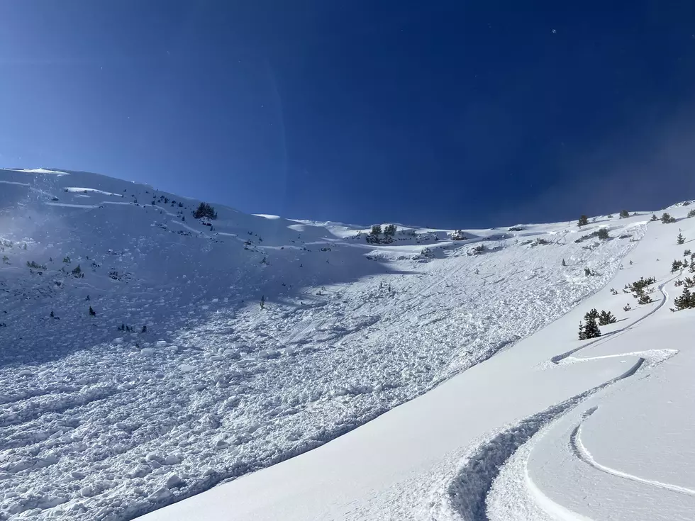
The mountains near West Yellowstone have been the big winner during this storm receiving about 20 inches of snow in the last 48 hours while other areas received about 10-12 inches. Generally the snowpack is strong and avalanches will mostly be confined to the new snow. Yesterday Doug and I skied near Hebgen Lake and found no weak layers in the snowpack similar to our findings near Lionhead, Teepee Basin, and the Taylor Fork area. We observed minor cracking in the new snow but felt safe skiing mellow slopes without wind deposited snow. Near Cooke City a skier observed a small avalanche on a NE facing slope and reported a skier triggered avalanche on an E facing slope near Lulu pass on Tuesday. This avalanche was about 100ft wide and 1 ft deep.
Although the snowpack is generally strong, some areas may have avalanches breaking into deeper layers of snow. Near Cooke City, a layer of small facets exists on all slopes about 3 ft deep though this layer hasn’t been very sensitive. Near the Bacon Rind drainage and near Flathead Pass, buried surface hoar has been found, and on the west side of the Bridger Range on S and W facing slopes, the snowpack is thin and weak. Today avalanches are most likely on wind loaded slopes which have a HIGH avalanche danger. Non wind loaded slopes that are steeper than 35 degrees have a CONSIDERABLE avalanche danger. Until the snowpack has time to adjust to the weight of this new snow, search for slopes without wind blown snow that are less than 35 degrees where the avalanche danger is rated MODERATE.
The northern Gallatin Range:
Unfortunately the northern Gallatin Range, including the Hyalite Canyon area, has only received about 6 inches during this storm. In simple terms, less snow means less avalanches and the snowpack was mostly strong and stable prior to this storm. The old snow surface was highly variable and the new snow needs some time to bond to it. Additionally, isolated areas contain some weak snow that will be stressed by the weight of wind deposited snow. For these reasons today, the avalanche danger is rated CONSIDERABLE on wind loaded slopes and MODERATE on all others.
We will issue the next advisory tomorrow morning (12/31) at 7:30 a.m. If you have any snowpack or avalanche observations, drop us a line at mtavalanche@gmail.com or call us at 587-6984.
More From KISS FM


![[WATCH] Terrifying Video Shows Snowmobiler Buried by Avalanche](http://townsquare.media/site/15/files/2022/01/attachment-Snowmobiler-Buried-in-Avalanche.jpg?w=980&q=75)